Prusik Peak, West Ridge 9-4-10

Washington state is a great place to live if you are into climbing. Mountaineers fly in from all over the world to enjoy what this area offers. We can drive to some of these awesome destinations in just two hours!

We seem to make it up to the Stuart range at least once every year. This time we climbed Prusik Peak. The approach to the peak was as good as the climb. We went right through the heart of the Enchantments. There was still a lot of snow up there feeding the numerous small lakes.

This photo shows the south side of the peak. We would climb the north side of the west ridge.

A group of climbers ahead of us on the route. Two of them were from Chile.

Mark finishing one of the 5.7 sections of the climb.

Doug near the summit.

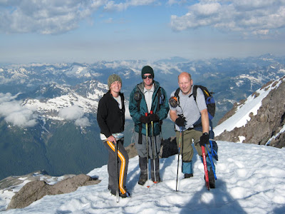
Another self-timer summit shot.

Little Annapurna, Dragontail Peak and some small lakes. What a view!

The fun was not over yet. It took 5 rappels to get back down.

We saw mountain goats all over the place on this trip.
It was another day making memories in a very special part of creation!

Glacier Peak 7-31-10

After years of trying, we finally made it up to climb Glacier Peak. At 10,541', it is the fifth highest peak in Washington. It is located northeast of Seattle, way out in the middle of nowhere. Luckily, all aspects of the 15 mile approach are beautiful. It is hard to keep your eyes on the trail. The forest features huge Douglas fir and cedar trees.

The trail goes through about 7 miles of forest and then climbs up to join the Pacific Crest Trail. The hillsides are covered in Heather and numerous wildflowers. We must have crossed 20 small streams on the way.

After almost 10 miles of hiking, we get our first look at the mountain. At this point we are still several hours from our high camp.

The clouds started to roll in during the night. We had to get going earlier than we had planned to try to summit while we had a chance. Our route took us over parts of the Gerdine and Cool Glaciers. This large crevasse was near Disappointment Peak.

Climbers nearing the top.

Emily, Doug and Dave on the summit. The Glacier Peak Wilderness is full of inviting snow covered peaks.

We broke camp and started the long hike back to the car. As we headed out, clouds began to cover the mountain. Pretty soon we could hear distant thunder.

We saw a few marmots along the way.

Tiger Lilies beside the trail.

We made it back to the car before dark. The downpour began soon after that.

With the low elevation trailhead, the long approach and a lot of ups and downs, this climb was as taxing as climbing Mt. Rainier. It was nice to finally stand on top of the mountain that we have seen so many times from other summits.

Mt. Rainier, Ptarmigan Ridge 7-18-10

Tina drove Mark and I around to Mowich Lake and dropped us off. We would have to climb Ptarmigan Ridge and descend the easier Emmons Glacier to get to the other car waiting at the White River Campground. This picture shows the northwest side of Mt. Rainier. Ptarmigan Ridge is on the left.

Moss covered rocks by a small creek.

The "entrance" to Spray Park.

Kids playing on the snow at Spray Park.

Colorful rocks and Indian paintbrush on the lower slopes of Ptarmigan Ridge.

This is what we came to climb! A steep 2,000' face, the icy chute below the buttress and a short rock climb.

Our route is shown in red.

The snow was absolutely perfect. It was firm, but not too hard for crampons or ice axes.

The air was about 40 degrees and calm. There wasn't any rock or ice fall while we were climbing.

Mark swinging his ice tool near the top of the face.

The sun rising near the Stuart Range as seen from 12,000'.

After climbing the face, we had two options. One was to go left and cross below a large ice cliff and get right on the Liberty Cap Glacier. We chose to go right, break out the ice screws and climb the icy chute below the rock buttress.

The ice was also in great shape.

The views looking down on the glaciers and valleys were amazing.

The last obstacle was this exit gully. It was a bit of a challenge to climb rock wearing crampons and carrying a large pack.

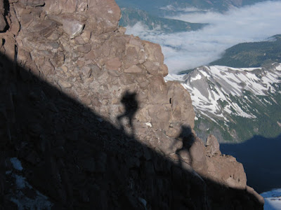
Our shadows projected onto the rock as we head towards Liberty Cap.

Climbers moving over the sun and wind sculpted snow at about 13,500'.

Mark checking out a bergschrund near the summit.

Doug and Mark on Liberty Cap.

A black bear at Glacier Basin.

It was a nice change to approach a climb on Mt. Rainier from a new area. It was great to finally make it up Ptarmigan Ridge. This is one climb we will never forget!

Mt. Adams, South Climb 7-10-10

Everyone relaxing around base camp after setting up tents and eating dinner.

It looks like the surface of the moon, but it is actually our high camp at Lunch Counter. Most of the tent sites were buried, so a bunch of us ended up setting our tents up on the snow.

It was a nice evening on the mountain with just a light breeze.


We had a dozen climbers reach the summit the next day. Our usual exhilarating mile-long glissade back to high camp was followed by a fast, fun descent on snow that extended most of the way back to the cars.

Mt. Rainier, Little Tahoma 6-18-10

Another wet weekend forecast for Mt. Rainier caused us to change our plans from a three day climb of the Emmons Glacier to a one day attempt on Little Tahoma. We spent most of the day walking on snow. Dave and Brad crossing over Fryingpan Creek.
Brad, Mark, Doug, Norm, Collin (and Dave) almost to Summerland. Little Tahoma is in the background. Our view of the summit did not last for long.
Collin and Norm nearing Meany Crest and the Fryingpan Glacier.
After going up the Fryingpan Glacier, we crossed a ridge to the Whitman Glacier. The five tiny dots are climbers from our group heading up into a lenticular dome (with GPS units on).
Mark, Dave (Doug, Norm and Collin) at our high point of 10,300'. Unsafe conditions and worsening weather made us turn around 800' from the summit.
Mark was able to ski about halfway back to the car. We enjoyed great views of Fryingpan Creek beside the trail. Although we did not summit, it was still good to spend the day outside exploring another part of creation with friends.

Mt. Hood 3-20-10


For our first climb of the year we went on a "winter" climb of Mt. Hood. This was an all-nighter. We drove down Friday evening and started hiking at about midnight. Mike and Mark, father and son, near the top of the ski area.


We climbed the Old Crater Variation. There was a constant shower of small pieces of snow coming off the cliffs above. Mark near the top, about 700' above the crater fumaroles.

We got to the top ahead of schedule. We wanted to see the sunrise from the top, so we killed some time by taking a chilly nap at 11,200'. It was worth the wait! Mark on top.

Doug on the summit.


We had to walk along the crater rim to get back to our route. To Mark's right is a 2,000' drop, to his left is a 700' drop into a fumarole. Not a good time to stumble!

Looking down into the crater and Timberline ski area. The line of snow on the left is the Hogsback. To the right of it are some fumaroles.
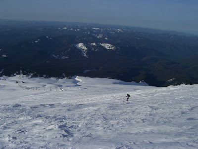

Mark had skinned up to 9,000' while Doug packed his skis and boots. It was nice to ski out in 15 minutes after taking 3 hours to climb up to that point. We could not have asked for better weather and snow conditions in March.