Lake Stuart and Horseshoe Lake 10/26/13

A bunch of the guys took advantage of another great forecast and went for a hike up to Lake Stuart and Horseshoe Lake.  They covered about 15 miles and 4,000 vertical feet.
 Ron, David F, Dennis, Dan, Pete, Jim, Todd and (David S)
Lake Stuart
The north side of Mt. Stuart
 Horseshoe Lake
So many beautiful places to see......so little time!

Mt. Aix 10/5/13

A few of the guys and their dogs took advantage of some great weather to climb Mt. Aix.  They took turns breaking trail through the fresh snow that was knee deep in places.
 Taking a break.
What a great view of Mt. Rainier!
Nearing the top.
Ron, Pete, Dan and Dave on the summit of Mt. Aix at 7766'.

Enchantments Traverse 9/14/13

After a weather delay, we were finally able to do the Enchantments Traverse.  We spent the day up in mountain goat country. That area is full of snowfields, steams, awesome lakes, granite boulders, slabs and peaks.  With our side trip to Little Annapurna, it ended up being an 18 mile hike.  The blisters should heal up in about a week :)
 At about 2 hours into the hike, we arrived at Colchuck Lake.  
A couple of hours later, we made it to the upper basin and started seeing mountain goats.
Then we ran into a few well-camouflaged Rock Ptarmigans.
 
We couldn't resist standing on the collapsed snow cave.
 Ron and Doug on top of 8,440' Little Annapurna.  Mt. Stuart and Dragontail Peak in the background.
Prusik Peak, Mount Temple and several of the alpine lakes. 
Little Annapurna as seen from Perfection Lake.

Some people say that this is the most beautiful place in Washington State.  We've been to some amazing places.  I can think of several that are close, but none better!

Goat Rocks 8/25/13

Emily, Ron, Nick, David, Dan and Doug arriving at Snowgrass Flats.
After setting up camp, we headed south to climb Mt. Gilbert.  Cispus Basin and the southwest section of Goat Rocks.
On day 2, we went north to climb Old Snowy.  Goat Lake and Mt. Rainier as seen from the Pacific Crest Trail.
A snowfield full of Watermelon Algae.
Wildflowers at Snowgrass Flats with Mt. Adams in background.

In addition to all the incredible sights, we got to pick sweet huckleberries all along the trail.  We just might have to plan another trip to this area!

Mt. Olympus, Blue Glacier 8/10/13

We made the long drive up to the northwest corner of the state to climb Mt. Olympus.  It is located deep in the Hoh Rain Forest.  The climb involves a round trip hike of 45 miles with an elevation gain of 8,000'.
There were huge, moss covered Douglas Fir, Cedar, Spruce and Hemlock trees everywhere.
Elk Lake at the 15 mile mark.
This cable ladder was put in place to help climbers cross an avalanche chute just before the camp at Glacier Meadows.

The Blue Glacier as seen from the lateral moraine.  The true summit is the farthest peak in the middle of the picture.  Snow Dome is on the right.

Doug and Dave on the summit in our rain gear.  It rained for about an hour when we first started up the glacier.  We had traveled and hiked way to far to turn around because of rain!  The sun even came out later that morning.
The view from the summit looking down on Snow Dome and the Blue Glacier.
 The lower part of the glacier is a square mile of hard ice.  It is covered with hundreds of small icy streams.  They usually disappear into a hole or crevasse on the glacier.  
It would have been easy to spend an entire day there exploring that part of the mountain.  We had to walk on the high spots to stay dry.

We made our way back down the moraine to Glacier Meadows where the biting flies convinced us to start the hike out to the car.  The next day, we stopped at the beach for a while and then started the long drive home.  It was nice to accomplish another climb that had been on our "to do" list for a while.

Mt. Adams, South Climb 7/13/13

The approach for the Mt. Adams South Climb looks very different this year.  Most of the trees in the Cold Springs area got burned up in the September 2012 fire.  

Lots of climbers heading up the slope that we call Widowmaker.

Hungry climbers waiting for the all you can eat dinner:  Chicken & Rice Casserole and Bacon Cheesy Potatoes!

Climbers stopping above Lunch Counter in the morning to put on crampons before heading up the south face.

700 vertical feet to go!

A big group celebrating on top of the second highest mountain in Washington!
Now for the fun and slightly scary part....the mile long glissade back down to high camp!
The crew feasting on BBQ cheese dogs, chips and pop.  What a way to end a great climb!

Mt. Rainier, Tahoma Glacier 7/6/13

We had been wanting to climb the Tahoma Glacier for quite a while and finally got our chance.  We started out on a Friday at a locked gate on the Westside Road.  Two of us walked while two rode mountain bikes for the first 3.5 miles of the closed section of the old Westside Road.  It seems like climbs with long approaches have great scenery along the way.  This was no exception.  One of the first sights were these towering Columnar basalt cliffs that are hundreds of feet high.
Crossing a footbridge over the South Puyallup River.
Avalanche Lilies growing alongside the trail.
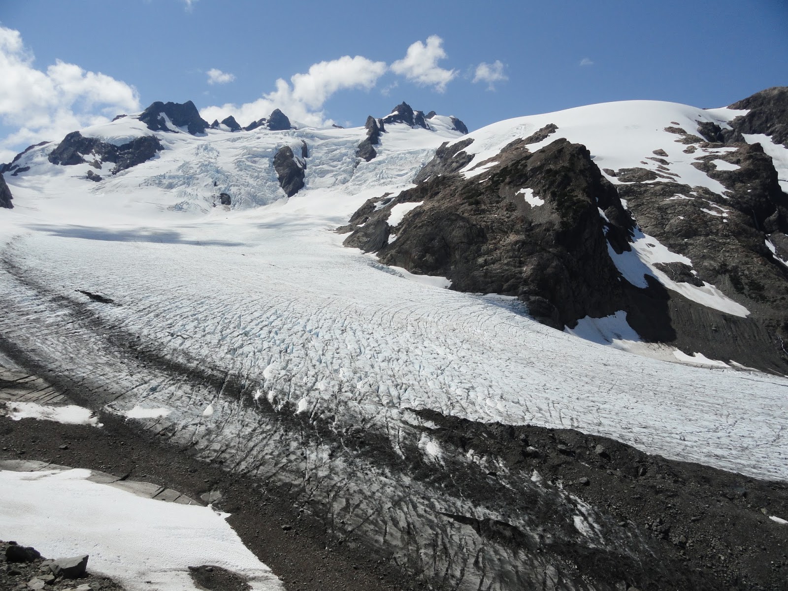
Our objective: the Tahoma Glacier, flowing from the summit down the west side of Rainier.  This photo was actually taken after the climb.  On our ascent, we had to find our way up the Puyallup Cleaver (left of center) in the fog and wind.  We finally climbed out of the fog at the 8,000' level and found a place to bivy.  After 2 hours of "sleep," when most people we know were just going to bed, we got up and continued up the cleaver to the 10,000' level.  It took quite a while to find a way around the cliffs and down onto the glacier.  That's when the real fun began...finding a way through the maze of huge crevasses. 
A drop-off on one side and a deep crevasse on the other!  Mt. St. Helens in the background.
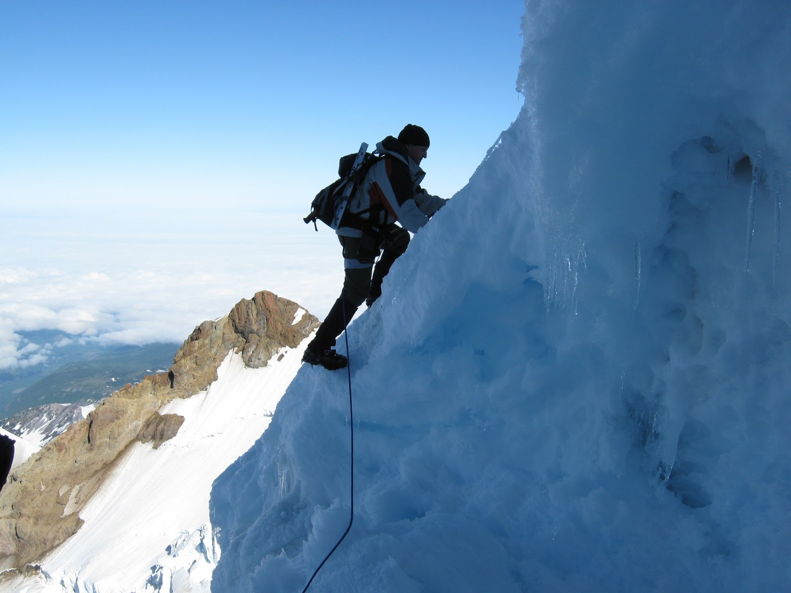
There were huge crevasses everywhere!  Each one is different and amazing.  You just want to stand there and look at the layers of snow, icicles and giant features of snow and ice that hang and span from one side to the other.  There is nothing like seeing one of these up close and in person.  
Our rope team moving up a steep section.
Ron climbing a snow ramp to the upper lip of another big crevasse.  
The team crossing a snow bridge to get by another one.
Slow and steady progress on a smooth part of the glacier.
Ron, David, Doug (and Mark) on the summit.
This debris filled crevasse was easy to cross.
We wanted a challenge and we got it!  With a low camp and a lot of route finding challenges, we ended up summiting late and then spent a couple of hours on the descent that afternoon postholing up to our knees in soft snow.  The 3 quarts of water that we each started out with was not enough.  We ate a lot of snow on the way down.  We finally made it back down to camp 24 hours after we started!  Needless to say, we slept really good that night!  Since we summited on Saturday, we were able to take our time getting up and heading out on Sunday.  We were all smiles as we headed back down to the treeline, stopping to look back at least a dozen times.  This climb starts way lower than most on Rainier and it has a lot of big ups and downs.  When we got back to the trailhead, the GPS unit indicated that we had climbed 15,000 vertical feet over a distance of 32 miles.  It's no wonder we were tired.  It was a weekend well spent making memories with good friends!  Out of all the climbs we have done, we all agree that this was one of the best!

Mt. Rainier, Disappointment Cleaver 7/4/13


Someone had this crazy idea to climb Mt. Rainier on the 4th of July to watch the fireworks from the top.  It might have worked, except it ended up being cloudy on the west side of the state!
We started out that morning and headed up the well worn, normally crowded, DC route.  By the time we got above Camp Muir, all the climbers for that day had already come down.  We had the entire upper mountain to ourselves!  The Ingraham Glacier, Ingraham Flats and Disappointment Cleaver.
David on the nose of DC.  Cadaver Gap and Mt. Adams in the distance.
David holding the hand line on the big traverse over to Gibraltar Rock.
David in the crater on the top of Mt. Rainier.
Doug in the crater.
The shadow of Rainier hitting some low clouds at sunset.  It was really strange and pleasant to climb that route and not see any climbers above high camp.  We did see a few distant fireworks in the Yakima area on our way down.  It didn't turn out the way we had hoped, but it was still a great day to try something new on our favorite mountain!